Monday, 29 October 2018

Machu Picchu

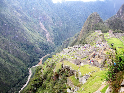
We took the train from Poroy, 20 minutes by taxi from Cusco, to Aguas Calientes - a very nice and relaxed three and a half hour journey through forests and mountains. There was spectacular scenery along the way and even though there were windows in the roof of the train, any photos would not have done it justice. From Aguas Calientes it was then a 30 minute bus ride up the mountain to join the hundreds of other people waiting to see this remarkable site. All the hiking and walking at altitude had paid off and even though I was not 100% and still on the road to recovery, I was still able to pass tour groups making their way up the many steps to the entrance. This is what was waiting for us:


This is the road the bus came up from the valley below, and of course, had to go back down again.


It was a long day but well worth it.

Lima to Cusco and back to the coast

We spent just over a week in Lima and during that time Mark had a dental implant done in place of the tooth he had extracted in Antigua Guatemala.  

We stayed at Miraflores near the coast and saw the statue of Paddington Bear. We also did a walking tour of the centre and saw many of the sights 


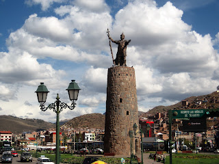
From Lima we decided to travel to Cusco by plane rather than drive the 2 days to get there. At 3,300m it certainly took our breath away. We were greeted at our airbnb with Coca tea. Not sure if it helped with the altitude but it was certainly welcome. Here are just a few photos of Cusco 


I came down with gastric flu just before leaving Lima so wasn't really up to exploring much of the surrounding area. Mark went on a day trip to the Sacred Valley and here are just a few of the pictures he took


From Cusco  we caught the train to Machu Picchu  (see next blog)

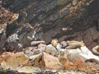
We then took the plane from Cusco back to Trujillo near the coast, picked up the car  and continued our journey south. We are now in the small coastal town of Paracas. Yesterday we went on a boat trip to the Ballestas islands, a national reserve also known as the poor man's Galapagos. We saw Humboldt penguins, sea lions, Peruvian boobies, pelicans and lots of seagulls. They also mine guano every 6 years and it pays off the national debt.


Next we'll head down to Nazca then inland to Arequipa 

Sunday, 28 October 2018

I hate winter

The clocks go back and all of a sudden it's dark in the afternoon, the leaves are off the trees and it's just cold and damp and gray and depressing all the way to midwinter and Yule......

Actually this afternoon is only about the third sunny day in Peru. It has been dull and gray and not particularly warm, even at the coast, let alone in the andes. Apparently being tropical it only gets around 12 hours of daylight so the temperature stays pretty even all year, but I seem to remember places in Africa and the Indian ocean and asia on the equator being significantly warmer. So that may be bullshit......

But it's Sunday afternoon, I'm drinking a local wheat beer of all things, just had a huge plate of spicy sea bass ceviche, which is my third favourite fish after dorado and tuna, and all is right with the world.....for now


Wednesday, 24 October 2018

Tasty

Still haven't tried guinea pig yet, but just had alpaca for lunch. They are only reared for fleece and meat, whereas larger llamas are also pack animals. They are both part of the camel family, which is a first for me.

Probably closest comparison with is with veal - quite lean but not tough or dry, and quite a delicate flavour - nowhere near as strong as lamb or goat, or fatty as pork, but a slightly darker meat than chicken or veal.i just had it seared with a little olive sauce - I think stewed or any heavier sauce would overpower it.

Tuesday, 9 October 2018

Ecuador coast to Peru Andes

From Montanito we headed inland to the mountains and the small town of Alausi. In 1895, the President of the Republic of Ecuador announced that a new railroad would be built to connect the coastal city of Guayaquill with the capital, Quito, in the highlands. Due to frequent earthquakes, heavy rains, wildlife (jaguars and poisonous snakes), malaria and yellow fever, building of the railway was not an easy task. Add into the mix the change in altitude from sea level to 2,800m and a massive lump of pure rock known as the Devil's Nose (Nariz del Diablo) meant that engineers needed to devise a series of steep curves and switchbacks where the train shunts back and forth therefore allowing it to climb the 1-18 gradient. The trainline operated until 1997 when a number of landslides devastated the tracks, closing the entire line. Now, there is a stretch that is open for tours and the views were amazing


The devil's nose


From Alausi we headed south in the highlands to the city of Cuenca. It is known as the most European city in Ecuador as it has many 16th and 17th century Spanish colonial architecture. The historical centre is also listed as a UNESCO World Heritage site


On the Sunday we decided to walk up to the lookout
 

Almost 600 steps later and out of breath, we reached the top (still at 2,550m). The view of the city below was well worth it

All this walking at altitude is standing us in good stead for when we get to Peru.

From Cuenca we drove down and crossed into Peru and spent the night at the coastal town of Mancora. Along the way we passed many shanty towns and the poorest areas of Central and South America that we've seen so far. From the coast we headed inland, had an overnight in the town of Olmos where election fever had gripped the locals and so making it an incredibly noisy night, then into the Amazon region and the mountains once more. We spent the afternoon hiking to Gocta Falls, the third largest in Peru with a height of 770m. Unfortunately the weather had started closing in so we didn't get to see the landscape and falls at its best, but we got to work the legs and lungs once more.


Wet and cold, we arrived in the town of Chachapoyas only to find election fever was there too. This town was just another overnighter to enable us to get to the tiny town of Nuevo Tingo the following day to visit the archaeological site of Kuelap, also known as the Machu Picchu of the north.  No election fever here, instead we were awoken to the noise of a braying donkey that sounded like he was being sawn in half. There is a cable car to the top that would normally take 20 minutes but this was closed for maintenance. Instead we drove up the winding mountain road that took almost an hour and a half. At the top we had to walk about 2kms up stone steps to the ruins. The view of the mountains below was worth it, even before we got to the ruins, and yes that is the road we drove around.


After all the walking and hiking that we've done at altitude lately, this wasn't that strenuous.

The drive from Nuevo Tingo, via Cajamarca to the coast was very tiring two days for Mark. Single lane dirt roads with potholes and ruts, and no barriers with vertical dropoffs were quite scary. I'm glad we were up in the clouds for some of it so I couldn't see the sheer cliffs. At one point a sign read 3.600m and I could see the top of the mountain range at the same level on the other side of the valley. This is one of the roads we drove up


Now it's time to head down to the capital, Lima